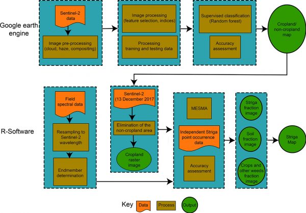
Information on parasitic and non-parasitic weed occurrence within croplands is vital but is often unavailable to support weeding practices and improve cropland productivity assessments. Until now, few studies have been conducted to estimate weed abundances within agroecological systems from spaceborne images over wide-area landscapes, particularly for the genus Striga. In this study, we attempt to increase the detection capacity of Striga at subpixel size using freely available spaceborne medium-resolution imagery in a two-step mapping approach. Firstly, we characterized the landscape in different classes including cropland using a 10-meter Sentinel-2 satellite image and Google Earth engine platform. Secondly, we determined if using a subpixel model i.e., the edge-cutting machine learning multiple endmember spectral mixture analysis (MESMA) in an exclusive cropland class that was accurately mapped in the first step, improves the detection and estimation of the level of infestation of Striga hermonthica at both field and landscape scales. Overall mapping accuracies obtained in the analysis showed that the MESMA provides plausible results for predicting the relative abundance of Striga within each Sentinel-2 pixel at a landscape scale. The capability of MESMA together with a cropland classification hierarchical approach was thus proven to be well suited for Striga detection in a heterogeneous agroecological system.
Mudereri, B.T., Adel-Rahman, E.M., Dube, T., Niassy, S., Khan, Z., Tonnang H.E.Z., Landmann, T., (2020). Science of the Total Environment. doi.org/10.1016/j.scitotenv.2020.143151